Exposure to environmental risk factors such as heat and air pollution, and the benefit attained from the development of green spaces, are important health determinants. The extent of exposure to these factors depends on geographical context (rural, urban, impact of land development on soil) and the interplay of complex physical mechanisms (e.g. impact of vegetation on air pollution and temperature, and vice versa). Exposure can also have synergistic effects on health. Heat and air pollution are associated with an increased risk of mortality and morbidity, as well as harmful effects on perinatal health. Conversely, the presence of vegetation reduces the risk of mortality and is positively associated with perinatal health. The most disadvantaged populations are more severely affected because they are more exposed to these risks and have fewer opportunities to benefit from green spaces due to structural factors, leading to environmental and social inequalities in health.
Reducing exposure to heat and air pollution and developing green spaces are interventions that bring health benefits. They form part of a strategy that promotes environments that are conducive to health, adapted to climate change, protect biodiversity and help to reduce greenhouse gas emissions.
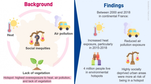
Understanding these exposures and cross-referencing them with social data is an essential step in identifying areas where multiple harmful exposures and social disadvantage cumulate, and for taking action. A study conducted by Santé publique France and INSERM, published in the Journal of Exposure Science and Environmental Epidemiology [1]*, examined the combination of exposure to heat and air pollution, lack of access to vegetation and social disadvantage from 2000 to 2018, both nationally and at a fine geographical scale. This work aimed to characterise the territory of mainland France so that the areas and populations most at risk can be prioritised for interventions.
3 questions for: Lucie Adélaïde**, Environmental and Occupational Health Division, Santé publique France

Exposure to vegetation has multiple beneficial health effects. Many studies have shown people living in areas with more green space to have better mental, cardiovascular and perinatal health. For example, the WHO French Healthy Cities Network considers urban green spaces to be a tool for promoting health and equity.
The mechanisms by which green space affects health are not yet fully known. Three main routes of action have been identified:
- Reducing exposure to environmental stressors: air pollution, heat, noise, etc.
- Opportunities for people to develop their potential by offering a space for physical activity, social contact, etc.
- Restoring people’s capacities through a psychological reset and reduction of stress
From a “One Health” perspective, a fourth factor can be added: the protection of biodiversity.
Since vegetation can reduce heat through shade and evapotranspiration, it has now found a place as a central tool in climate change adaptation policies.
The health impacts of heat, air pollution and vegetation are often studied independently. However, the interconnection that exists between these three factors raises the question of whether they may have synergistic effects on health. Little is known about these potential effects due to a lack of investigation.
A first step in studying these combined effects is the cross-referenced description of exposure to the three factors at a fine scale, nationwide and over a long time period, which had never been done before. For this project, we created relative indicators that are comparable across the whole country. This approach took the diversity of climates and vegetation in France into account, and meant that we avoided the issue of having to use absolute values based on temperature or the NDVI (a satellite index measuring chlorophyll activity), which are difficult to compare from one region to another.
Defining these exposures meant that we could identify environmental hotspots, which were the areas with the highest overexposure to heat, air pollution and lack of vegetation, and study their association with social disadvantage.
This study found that there was greater overexposure to heat during the period 2015–2018 than in 2000–2014, which is consistent with the climate trends that have been observed in France. Looking at ambient air pollution, air quality in terms of the majority of pollutants improved between 2000 and 2018, but in 2018 most of the urban areas studied were still above the 2021 WHO recommended values for air quality. For example, 99.9% of urban areas had concentrations of fine particles (PM2.5) above the recommended values. On average, 7% of the areas studied combined the highest overexposure for the three factors studied (environmental hotspots). This percentage was similar for both rural and urban areas.
Finally, the most deprived urban areas were at higher risk of being environmental hotspots. This was not a finding seen in rural areas, which can probably be attributed to a more uneven distribution of disadvantage and larger spatial scales than were used in urban areas.
Source: J Expo Sci Environ Epidemiol - Design: Lucie Adelaïde
By exploring the combined exposure to heat, lack of vegetation and air pollution nationwide and alongside social disadvantage, our results are in line with the strategies set out in France’s second climate change adaptation plan and fourth national health and environment plan, with social inequality to be taken into account and incorporated into environmental health actions. This study invites local stakeholders to address the issue of environmental justice in their adaptation policy by offering them tools to make comparisons between regions at a fine spatial scale. This could, for example, mean that certain regions with more significant combined exposure and greater social disadvantage could be prioritised, while taking into account specific features and contexts locally.
With the next batch of data to be made available on https://www.data.gouv.fr/, the environmental exposure indicators created as part of this study will be available for studies into the combined effects of temperature, air pollution and vegetation on health, in connection with social inequalities. For example, we are studying the effects of heat, co-exposure (air pollution, vegetation) and socioeconomic status on perinatal health, a major public health issue.
It is also important to note that we could not include the overseas departments and regions (DROM) in this study because the necessary data were not available, although these regions are particularly vulnerable to climate change. Work is ongoing to assess the relevance and feasibility (whether environmental data is available and accessible, etc.) of extending this study to the DROM.
This research meets the need for deepening our knowledge so that equitable and fair climate change adaptation can be implemented.
* The version of the manuscript submitted for publication (not peer reviewed) is available in open access on HAL: https://hal.science/hal-04444139
**This work was carried out as part of a thesis funded by Santé publique France, co-directed by Santé publique France and INSERM in association with the Public Health Doctoral Network coordinated by the École des hautes études en santé publique (EHESP) [School of Public Health].
Open data and provision of data
All exposure data obtained, by municipality and by IRIS [Ilots Regroupés pour l’Information Statistique; grouping zones for statistical information], and analysed in this study is available as open data. The data can also be obtained on request from the authors.
These data by municipality and by IRIS were calculated using gridded data (200 m² to 4 km²) derived from innovative exposure models and covering the entire territory (1-3). These data are available on request from the authors (johanna.lepeule@univ-grenoble-alpes.fr for PM and temperature data).
- Hough, et al. Gaussian Markov Random Fields Improve Ensemble Predictions of Daily 1 km PM2.5 and PM10 across France. Atmospheric Environment (2021).
- Hough, et al. A Multi-resolution Air Temperature Model for France from MODIS and Landsat Thermal Data. Environmental Research (2020).
- The NO2 and O3 data are available from INERIS
Learn more about social inequalities in health and exposure to heat:
- Forceville, Gauthier, et al. “Spatial contrasts and temporal changes in fine-scale heat exposure and vulnerability in the Paris region”. Science of The Total Environment, vol. 906, January 2024, p. 167476. ScienceDirect.
- Excessive heat, heatwaves file (French only)
- Air pollution and health file (French only)
- Health as a lever for action on climate change – Symposium of 8 April 2022; Insights, ed. Santé publique France, February 2023
- France’s National Plan for Adaptation to Climate Change (PNACC-2)
- France’s fourth National Plan for Health and the Environment (PNSE 4): "One environment, one health" (2021–2025)
- Urban planning dedicated to health; La Santé en action, n°459, March 2022